Winchester Oil Pipeline Project
This scoping report is to provide Seascape Oil Networks Limited with an overview of the proposed 600mm diameter oil pipeline project that will run from a point on the National Transmission Pipeline north of Winchester to the Regional Transmission Pipeline to the south and to invite early input from the developers in the identification of key issues, areas of concern and additional environmental data available in order to inform the detailed Environmental Impact Assessment (EIA) scoping process.
1. Introduction
1.1 This Report
This is a desktop constraints report for the impact assessment of a proposed oil pipeline construction by Seascape Oil Networks Limited. This study aims to identify the significant environmental, archaeological and socio-economic impacts that will be addressed in the Environmental Impact Assessment (EIA) process by:
- highlighting sensitive features of the existing environment;
- identifying project elements that have environmental impact potential;
- proposing the pipeline route and mitigation measures to minimise impact.
1.2 Project Objective
Seascape Oil Networks Limited is proposing to construct a new pipeline for oil transportation from the National Transmission Pipeline (approximately 2.8km west of South Wonston) to the Regional Transmission Pipeline (2km southeast of Winchester) in the county of Hampshire, United Kingdom (UK). The selected corridor for the pipeline route is illustrated in Figure 1.1
1.3 Legislative Framework
The Pipeline Act 1962 requires that a Pipeline Construction Authorisation (PCA) be obtained from the Secretary of State for the construction of an on-shore pipeline in the UK. The proposed project is also subject to the Pipeline Works (Environmental Impact Assessment) Regulations (2000) which stipulate the need of an EIA for pipeline construction for oil transportation.
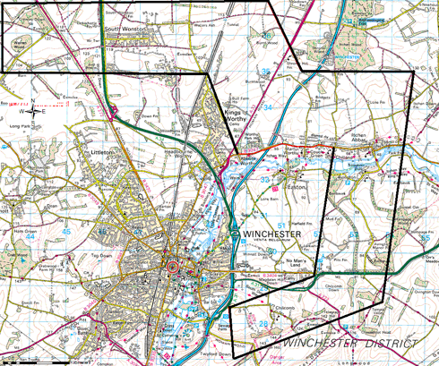
Figure 1.1: Winchester and selected corridor (Source: OS Explorer Map).
Other supporting legislation includes the EC Directive 85/337/EEC (Assessment of the Effects of Certain Public and Private Projects on the Environment), EC Directive 92/43/EC (Habitats Directive), EC Directive 2009/147/EC (Birds Directive), the UK Wildlife and Countryside Act (1981), Hedgerows Regulations (1997) and the UK Conservation of Species and Habitats Regulations (2010).
2. The Proposed Project
2.1 Overview
This project is situated within the jurisdiction of the local planning authority of Winchester City Council. The route selection has taken into consideration the Council’s relevant planning policies and objectives.
The selected corridor for the construction of the pipeline is influenced by the position of the connecting pipelines (the National Transmission Pipeline and the Regional Transmission Pipeline) and the initial engineering feasibility study received.
The primary objective is to select an economically viable route with minimised impacts and risk to the public and the environment.
This preliminary route selection was conducted using Ordnance Survey mapping, GIS datasets from statutory consultees (English Heritage, Natural England) and the local council database.
2.2 Pipeline Construction
The proposed pipeline is 600mm in diameter and will be buried throughout its entire length with a minimum cover of 1000mm with no above ground structures.
The standard dig trench lay technique is assumed; however, tunnelling and other trenchless construction techniques will be required at environmentally sensitive areas, river crossings and at interceptions with major traffic routes.
Pipeline construction is carried out within a 50m working width, which would include a temporarily fenced corridor for storage of stripped topsoil, trench excavation and access road for construction traffic. The excavated trench is back-filled with the material taken from it in reverse order and the working area is returned to original condition as pre-arranged with landowners, statutory and non-statutory consultees.
2.3 Pipeline Operation
The use of an integrated corrosion protection system to secure pipeline integrity and periodical monitoring in line with existing maintenance schedules.
3. Environmental Assessment
The UK EIA regulations require a description of potential concerns/environmental aspects that are expected to be significantly affected (including land use, population, ecology, water, air, geographic, cultural/materials assets, landscape and the inter-relationship between them) by a project and the mitigation measures to minimise such effects to be reported in the Environmental Impact Assessment (EIA).
The significant impacts expected from the development of this project, and which will be identified in the EIA, have been categorised under the construction and the operational stages. Table 1 below shows the occurrence and types of impact of these potential concerns.
Table 3.1: List of potential impacts and their occurrence.
| Impact type | Construction | Operation |
| Landscape and visual impacts | -ve | Unlikely |
| Land use | -ve | -ve |
| Soils and agriculture | -ve | Unlikely |
| Biodiversity and habitats | -ve | Unlikely |
| Water resources and flood risk | -ve | Unlikely |
| Archaeology and cultural heritage | -ve | Unlikely |
| Emissions | -ve | Unlikely |
| Contaminated land and waste management | -ve | Unlikely |
| Traffic and transport management | -ve | unlikely |
| Socio-economic | +ve | Unlikely |
The buried nature of the project accounts for most construction impacts. The effects of most of the impacts are short-lived, occurring for specific periods during construction.
Other concerns that have been scoped out of the EIA for the insignificant impacts that they have include:
- Climate and topography: The project will have no impacts on the climate and topography of the selected area;
- Safety: The pipeline will be designed and constructed in line with relevant codes of practice;
- Geology and mining: The bedrock of the area is dominated mainly by chalk, mixed with a combination of clay, silt and sand occurring together or in layers. There are no recorded geological faults and mining activities in the proposed route. However, the impact of the pipeline construction is limited to a laying depth of 1000mm that affects mainly the surface topsoils.
4 Landscape and Visual Impacts
This component includes effects that the project might have on the appearance of the land, resulting in alteration of the present character, quality and views experienced by the inhabitants of the designated site.
The selected corridor has a varied landscape with different features including arable farmland, clay lowland pastures, chalk downland, river valley and woodland including Avington Park, a designated Parks and Garden. However, noticeable impacts on the character of the area will occur during the summer construction phase in the visual range of the pipeline route and its working areas.
The proposed pipeline is a buried structure, therefore impact is temporary, as restoration to the original state is done immediately after the pipe is laid.
5 Land Use
A large proportion of land on the proposed route is currently for arable farming and pasture fields, nature conservation sites and a few built-up urban/residential areas. There is a temporary land take for construction and it will be kept within the working width.
There will be temporary disruptions on the farms, due to restrictions placed on movement of livestock and farming machinery by the fenced working width. However, the project is controlled to ensure proper restoration to the original condition.
Construction activity in the urban areas limits road and street accessibility to residents. All existing cables and pipes on the route will be located by excavation to confirm their exact location; however, other utilities including sewage pipes will create constraints.
The project has the potential to restrict future developments on its route.
6 Soils and Agriculture
The temporary loss of land use in the construction phase of this project will hinder livestock movement and farm machinery, affecting pasture and cropping patterns. Creation of temporary access across the working width and alternative drainage systems would help to minimise the impact.
Other actions to mitigate impact could include refilling of trenches by excavated soil to ensure quick re-instatement of the land; the use of low ground pressure vehicles and back-actors in soil stripping to minimise soil compaction.
Construction is a relatively short-term activity spanning a few months and the land would thereafter be restored to its original condition.
7 Biodiversity and Habitats
This component involves the establishment of baseline ecological conditions and the evaluation of existing resources to identify the impact of the intended project on the flora and fauna, relating to the variety of species and habitat. The review of the Winchester Biodiversity Action Plan (BAP) shows areas of statutory and non-statutory nature conservation.
The selected corridor lies within several conservation areas, including ancient woodlands, Sites of Importance for Nature Conservation (SINC), Sites of Special Scientific Interest (SSSI) and a Special Area of Conservation (SAC), as shown in Figure 7.1. The designated conservation areas are reservoirs for biodiversity and preservation of habitats.
A large portion of land on the proposed route is used for agricultural activities, under the environmental stewardship scheme to promote farming compatible with the maintenance of the countryside and protection of the environment.
Conservation of biodiversity resources is usually enhanced by restricting developments in designated areas (SACs and SSSIs), ancient woodlands and networks of natural habitats (including hedgerows, field margins, river valleys and flood plains).
The major site of ecological importance is found at the River Itchen. This river is a classic chalk river, which serves as natural habitat for several numbers of national and international priority species including the water-crowfoot (Ranunculus penicillatus), Otter (Lutra lutra)*, Water vole (Arvicola terrestris)* and the Southern damselfly. The ecology on the river depends on its flow and water level, hence any disruption presents a threat to the nature conservation and the adjoining flood plain.
Other noted fauna recorded in the working area include the Duke of Burgundy (Hamearis lucina)*, Hazel dormouse (Muscardinus avellanarius)*, Barn owl (Tyto alba), Snipe (Gallinago gallinago)*, Great crested newt and badgers.
Due to the high sensitivity, consultations with the following groups must take place before and during construction:
- The Environmental Agency
- Natural England
- Hampshire County Ecologist
- Hampshire Bat Group
- Hampshire Ornithological Society
- Hampshire Amphibian and Reptile Group
- Hampshire Flora Group
- Hampshire Biodiversity Information Centre; and
- The BSBI recorder for Winchester
The impact on the areas of conservation would be reduced by the consideration of trenchless construction methods.

Figure 7.1: Habitat and biodiversity in the selected corridor
8 Water Resources and Flood Risk
To assess the effects of project construction with respect to surface water, drainage and ground water. A flood risk assessment is required by the Environmental Agency and the local planning authority for project proposals in Flood Zones 2 and 3. The selected corridor passes through Flood Zones 2 at South Stoke, at farm area in Kings Worthy and in the River Itchen valley.
Although trenchless construction techniques are proposed for the River Itchen are, consultation with and approval from the Environmental Agency is required for the conservation of the river’s prominent feature as a classic chalk river from aquifer-fed springs.
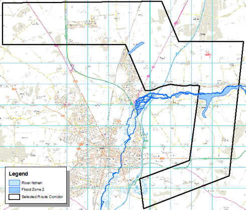
Figure 8.1: Water resource and flood risk areas in the selected corridor
Construction activity is temporary in nature and would be carried out during periods of low flooding risk; however, pipelines would be weight-coated to avoid flotation.
9 Archaeology and Cultural Heritage
The earliest recorded settlement in the Winchester area dates back to 150BC in the Iron Age and has since gathered rich diversity in historical background from the Romans, the Saxons, and the Normans. This is an indication of potential archaeological findings on any selected route.
There are over 30 listed buildings and 15 scheduled monuments in the selected corridor, as illustrated in Figure 9.1; however preliminary consultation with the Winchester County Archaeologist is essential before and during archaeological work.
The proposed pipeline route would be selected to avoid all archaeological and heritage sites in the working route; however, field evaluation is proposed to reduce the risk of damaging any archaeological features.
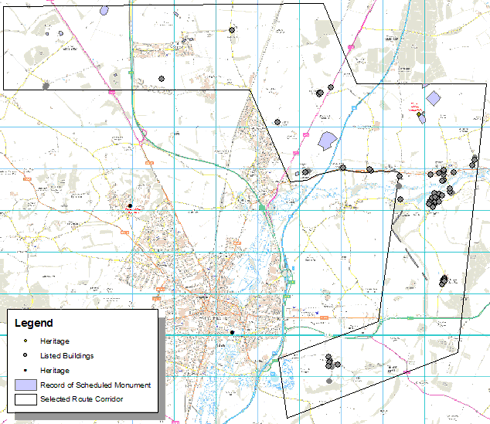
Figure 9.1: Archaeological and heritage sites in the selected corridor.
10 Emissions
The pipeline construction has the potential to generate substantial emissions in terms of noise, vibration, dust generation, air quality impacts, combustion emissions from plants and vehicles, transfer of mud onto public highways and discharge to watercourses. The extent of impact is dependent on the efficiency of control measures and the nearness to people and residences.
The emissions are temporary and spatial as they only occur in short periods of time in the work areas.
11 Contaminated Land and Waste Management
Registered industrial pollution and landfill sites that will be avoided in the selected corridor are listed below:
- Star Energy Oil UK Limited (oil pollution)
- Pentex Oil UK (oil pollution)
- Humphrey Farms (agricultural pollution)
- Alresford Drove (commercial landfill site)
- Morestead Sewage treatment works; and
- Landfills at the railway cutting in Manor Farm, Itchen Stoke.
A possible case of contaminated land may arise at the old Royal Air Force Base at Worthy Down Camp. Other potential sources of unrecorded contaminated sites may be present, which will be mitigated by the use of clay plugs in the pipeline trench.
Waste materials generated as a result of the pipeline construction must be handled in line with the Code of Practice for waste minimisation and recycling in construction. Suitable disposal routes and treatment methods will be adopted to mitigate the impact. Minimal impact is expected as the excavated soil would be reused in covering trenches.
12 Traffic and Transportation
The pipeline construction will impact road users by causing temporary increase in traffic flows and delays.
An appropriate traffic management system is required to identify potentially sensitive facilities such as schools, and detail agreed traffic routes. The measures may include announcements of future delays and diversions, road signs, traffic signals and temporary fencing.
The working area could be limited to one lane on roads and streets to reduce the length of trenched road at any time. To ensure minimised traffic impacts, all major roads (M3, A272, A31, A33, A34, B3047) crossings by the pipeline will be constructed using trenchless techniques.
13 Socio-economic Impact
The project would impact positively on the economic activities of the community during the construction phase. There would be compensation made to farmers and landowners for temporary and permanent land use, increased local employment opportunities dependent on contractor requirements and income generation from local procurements and expenditure.
However, these positive impacts diminish with the completion of construction.
14 Recommendations and Conclusion
The consideration of the identified potential concerns related to the design and construction of the pipeline would ensure that best environmental practices are followed. A comprehensive Environmental Management System will be drawn up for the project, to serve as a guideline to ensure both economic and practical considerations are taken into account when constructing the pipeline.
The recommended pipeline route from preliminary study is a 17.8km route from estimated point of inception to termination as detailed in the subsequent figures.
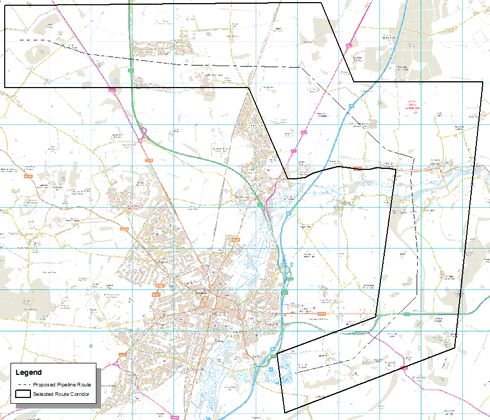
Figure 14.1: Proposed pipeline route in the selected corridor.
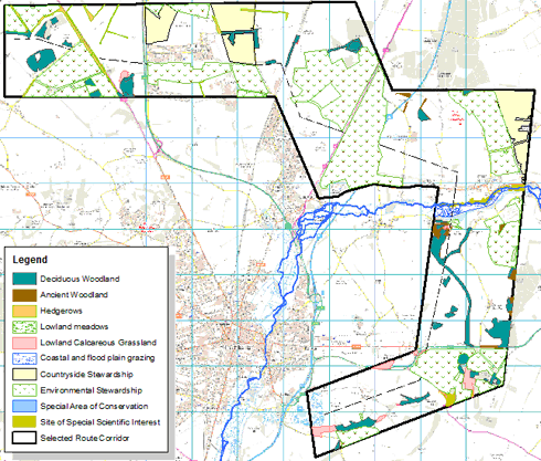
Figure 14.2: Proposed pipeline route in the selected corridor highlighting biodiversity and habitat.
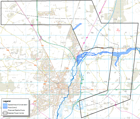
Figure 14.3: Proposed pipeline route in the selected corridor highlighting water resources and flood risk.
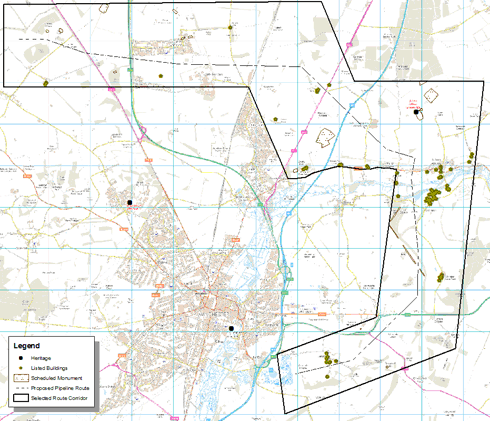
Figure 14.4: Proposed pipeline route in the selected corridor highlighting archaeological features.
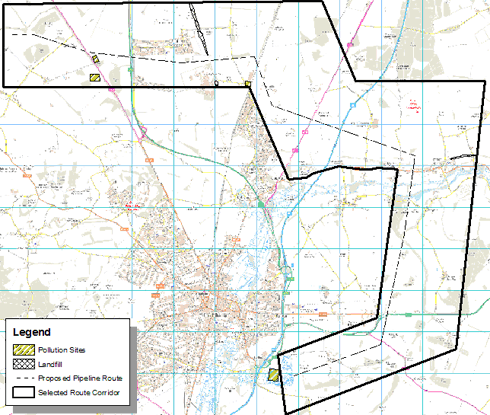
Figure 14.5: Proposed pipeline route in the selected corridor highlighting pollution sites and landfill areas.
Appendix: Impact Summary and Proposed Mitigation Measures
| Impact type | Environmental impact of the project | Mitigation measures | ||
| 1 | Landscape and visual impacts | Disruption to landscape elements in the working area, including farm lands, hedgerow and Avington Park | The visual effect is temporary in nature, due to the buried nature of project, lasting the time required for re-instatement. However, trenchless techniques are proposed for hedgerows and Avington Park | |
| 2 | Land use | Disruption of accessibility to farmland and residents | Provision of alternative routes | |
| Restrictions of future developments on pipeline route | Compensation clause in agreements with landowners | |||
| 3 | Soils and agriculture | Disruption of farming activities during project construction | Provision of access across working width and temporary drainage systems | |
| Crop loss on land used for working width | Re-instatement of farmland to original condition after construction | |||
| Harm to plants and animals | Effect measures to prevent introduction of weeds and spread of animal and plant diseases | |||
| Damage to topsoil and subsoil | Compaction risk could be reduced by constructing in summer and restriction of machine movement in wet weather | |||
| Soil can be stripped and stored in layers and back-filled in reverse order to ensure quick re-instatement | ||||
| Use of low ground pressure vehicles and back-actors in soil stripping to minimise soil compaction | ||||
| 4 | Biodiversity and habitats | Project impact to the aquatic habitats and species at the Itchen River | Employing non-open-cut construction techniques would ensure that the habitat and species are not affected by the pipeline | |
| Project potential to alter floodplain grazing habitat | Construction through the floodplains should be carried out during the periods of lowest precipitation and flood risk. Pipe should be weight-coated to avoid floating during flooding periods | |||
| Impact on woodlands, tree-lines and individual mature trees | Pipeline route has been selected to avoid trees wherever possible making use of hedge gaps and using of non-open-cut techniques at Avington Park | |||
| Disruption to hedgerows, reptiles, dormice, birds and bat habitats | Working width would be reduced in passages through hedgerows and by non-open-cut techniques if necessary | |||
| Working width and hedgerows will be reptile-proof fenced to prevent animals straying into the working area | ||||
| Disturbance to birds | Minimise effects on nesting birds by removal of possible nesting sites before the nesting season | |||
| Disturbance to bats | Bat roost trees will be avoided wherever encountered | |||
| Disturbance to badgers | Avoidance of badger sets wherever possible; however, badger ramps will be provided over the pipeline trenches | |||
| 5 | Water resources and flood risk | Effects to surface watercourse including River Itchen | Pipeline crossing using trenchless techniques | |
| Project impact on the floodplains | Summer construction period to ensure low water levels allowing floodwater gaps in the overlying soil | |||
| Spillage and other contaminants polluting surface and ground water | Construction of bunds for storage and in compliance with relevant regulatory practices | |||
| Pipeline trench acting as a new channel for water flows | Installation of clay plugs and land drainage designs to maintain pre-existing pattern | |||
| 6 | Archaeology and cultural heritage | Potential disturbance and destruction of archaeological materials | Pipeline route has been selected to avoid all statutory protected sites and archaeological features | |
| Further archaeological survey of the pipeline route to locate any previously unknown feature | ||||
| 7 | Emissions | Construction noise from plant and machinery | The use of silenced compressors and acoustic covers on plant and machinery. Use of acoustic barriers and informing residents of expected increasing noise levels | |
| Dust generated from construction activities | Use of water spray along the working corridor to moisten the soil surface and reduce dust generated. Speed limit for vehicles along the route to minimise dust generation | |||
| Air quality impacts from combustion emissions of plants and vehicles | All plants and vehicles would be switched off when not in use to minimise emissions of fumes and smoke | |||
| Pollution of public roads and highways | Cleaning of vehicle tyres before leaving working areas to reduce mud transfer to roads and highways. Utilisation of road sweepers to reduce mud accumulation on roads | |||
| 8 | Contaminated land and waste management | Impacts on the registered pollution sites | Selected pipeline route to avoid all known and recorded pollution sites | |
| Waste produced as a result of construction activities | Excavated soil would be used in back-filling the opened trench. Other waste would be moved using covered skips and containers. | |||
| Waste management plan to identify likely waste, handling and disposal methods in line with all relevant regulations. | ||||
| 9 | Traffic and Transport management | Disruption to normal traffic flow experienced by residents and other road users | Comprehensive traffic management plan to identify road constraints and sensitive areas including schools and hospitals and provide alternatives | |
| Daily cyclic work to limit stretch of open trenched road at any one time. | ||||
| Advance warnings to residents and other road users of intended disruption to road use. | ||||
| Use of trenchless techniques in pipeline crossings of the the M3 highway and other A-class roads. | ||||
| 10 | Socio-economics | Effects to socio-economical activities | Compensation to Landowners and farmers for temporary landtake and restrictions in further developments | |
| Income generating from project’s local procurement and expenditure | ||||
| Employment opportunities for the local populace in the community | ||||
Bibliography
Department for Environment, Food and Rural Affairs & Natural England Magic map [Online]// – November 24, 2010 – http://www.magic.gov.uk/
Digimap Collections – http://edina.ac.uk/digimap
Environmental Resources Management Ltd Albury Gas Storage Project: Scoping Report for Star Energy Gas Storage Services Ltd [Online]// Albury Gas Storage Project. Environmental Resources Management Ltd, May 25, 2007.- November 1, 2010.- http://www.alburygasstorage.info/downloads/alburyscopingreport.pdf.
Natural England GIS Datasets [Online]// Natural England. – November 20, 2010 – http://www.gis.naturalengland.org.uk/pubs/gis/GIS_register.asp
Natural England Nature on the Map [Online]// Natural England – November 20, 2010 – http://www.natureonthemap.org.uk/
Ordnance Survey Explorer Map [Online]// – November 24, 2010 – http://www.ordnancesurvey.co.uk/osbwebsite/getamap/
RWE npower Willington C CCGT Power Station, Environmental Impact Assessment Scoping Report [Online]// Npowermedia centre – RWE npower, April 2009 – November 1, 2010 – http://www.npowermediacentre.com/imagelibrary/downloadMedia.ashx?MediaDetailsID=5242.
UK Environmental Legislation Website Oil & Gas UK [Online] // Oil & Gas UK Environmental Legislation Website – Oil & Gas UK, 2010 – October 28, 2010 – http://www.ukooaenvironmentallegislation.co.uk/Contents/Topic_Files/Onshore/EIA_Pipelines.htm.
The United Kingdom Legislation Pipelines Act 1962 [Online] // Oil and Gas UK, Environmental Legislation – September 1, 2010 – October 28, 2010 – http://www.ukooaenvironmentallegislation.co.uk/Contents/Topic_Files/Onshore/EIA_Pipelines.htm.
The United Kingdom Legislation The Pipe-line Works (Environmental Impact Assessment) Regulations 2000 [Online] // The United Kingdom Legislation – The National Archives, 2000 – October 28, 2010 – http://www.legislation.gov.uk/uksi/2000/1928/made.
URS Australia Pty Ltd Final Report: Desktop Assessment of the Pipeline Northern Alternative Route; Prepared for Santos Ltd [Online]// GLNG – URS Australia Pty Ltd, March 22, 2009 – November 1, 2010 – www.glng.com.au/library/EIS/Appendices/AA
The Wildlife Trust, Hampshire & Isle of Wight Winchester BAP – a local biodiversity action plan for the district of Winchester (Executive Summary) [Online]// Winchester City Council – November 2005 – November 24, 2010 – http://www.winchester.gov.uk/Documents/Planning/1app/Winchester%20LBAP%20Executive%20Summary.pdf.
Natural England Land Character Assessment [Online]// Natural England – November 20, 2010 – http://www.naturalengland.org.uk/ourwork/landscape/englands/character/assessment/default.aspx
Winchester City Council Landscape – Character Assessment – March 2004 – November 25, 2010 – http://www.winchester.gov.uk/EnvironmentAndPlanning/LandAndPremises/Landscape-CharacterAssessment/
The Wildlife Trusts, Hampshire & Isle of Wight Winchester BAP – a local biodiversity action plan for the district of Winchester (Final Report) [Online]// Winchester City Council – November 2005 – November 25, 2010 – http://www.winchester.gov.uk/Documents/Planning/1app/Winchester%20LBAP%20Final%20Version.pdf.
Department for Environment, Food and Rural Affairs & Natural England Magic Map [Online]// – November 24, 2010 – http://www.magic.gov.uk/
Environment Agency Winchester – River Itchen SAC [Online]// Environment Agency – 2010 – November 25, 2010 – http://www.environment-agency.gov.uk/static/documents/Business/river_itchen_sac1888068.pdf
Hampshire Biodiversity Information Centre Biodiversity Information// Hampshire County Council – November 25, 2010 – http://www3.hants.gov.uk/biodiversity/hbic
The United Kingdom Legislation The Hedgerows Regulations 1997 [Online] // The United Kingdom Legislation – 1997 – November 24, 2010 – http://www.legislation.gov.uk/uksi/1997/1160/contents/made.
The Wildlife Trusts, Hampshire & Isle of Wight Winchester BAP – a local biodiversity action plan for the district of Winchester (Final Report) [Online]// Winchester City Council – November 2005 – November 25, 2010 – http://www.winchester.gov.uk/Documents/Planning/1app/Winchester%20LBAP%20Final%20Version.pdf.
Winchester City Council Biodiversity Help List for Planning Applications [Online]// – 25 February 2008 – November 25, 2010 – http://www.winchester.gov.uk/Documents/Planning/1app/WCC%20biodiversity%20checklist.pdf
Environment Agency Winchester – Water resources [Online]// Environment Agency – 2010 – November 25, 2010 – http://maps.environment-agency.gov.uk/wiyby/wiybyController?x
Department for Environment, Food and Rural Affairs & Natural England Magic Map [Online]// – November 24, 2010 – http://www.magic.gov.uk/
English Heritage – GIS datasets on archaeology and heritage [Online]// English Heritage – 2010 – November 25, 2010 – http://services.english-heritage.org.uk/NMRDataDownload
Hampshire County Council Archaeology and Historic Buildings Record// Hampshire County Council – November 25, 2010 – http://www3.hants.gov.uk/landscape-and-heritage/historic-environment/archaeology.htm
Environment Agency Winchester – Pollution and Landfill [Online]// Environment Agency – 2010 – November 25, 2010 – http://maps.environment-agency.gov.uk/wiyby/wiybyController?x
Winchester City Council Development on potentially contaminated land// Winchester City Council – May 2005 – November 25, 2010 – http://www.winchester.gov.uk/Documents/Pollution/Developmentof ContaminatedLand.pdf