Essay on Hazards and Mitigation Strategies
Number of words: 1935
Introduction
A hazard is a naturally occurring event that has a negative effect or threat on humans and the physical environment (NASA, 2021). When a hazardous event occurs and causes extreme harm to the environment and humans negatively it is called a natural disaster. A hazard can be natural or human-made. Natural hazards are a result of naturally occurring processes that operate throughout the earth. On the other hand, man-made hazards are triggered by some of the human activities carried out. For instance, when people crowd into low-lying areas or flood plains, they are exposing themselves to risk by increasing the severity of potential floods. Hazards have significant impacts on the economy, social and environment. The severity of the impacts of hazards depends on the details of human development decisions and the physical nature of the harmful event. The servility of a disaster is usually measured by the number of deaths it has caused or the cost of the damages it has caused.
This paper defines different types of hazards and the variables that trigger each hazard. It focuses on how these hazards are monitored and explains some of the mitigation strategies used to reduce the risks of the hazard. Lastly, the paper discusses ways in which we plan for or predict future hazards in space and time.
Hazards
Hazards can be caused by several factors such as weather, geological processes, biological factors, or hydrological processes. There are several types of hazards. Examples of hazards include; earthquakes, floods, landslides, drought, hurricanes, volcanic eruptions, infectious diseases, among others. This study focuses on earthquakes and floods types of hazards.
Climate Change
Climate change is the rise of average surface temperature on earth. It is refered to as global warming (NASA, 2021). It is caused by human use of fossil fuels which emits gases such as carbon dioxide. The gases trap the heat in the atmosphere leading to rising seal levels and droughts.
Drought
With the trends of climate change and global warming, droughts has been occurring all over the world. Drought is a period of drier-than normal situations that occur due to weather and hydrological factors (Society, 2021). Water shortage due to lack of precipitation like snow, rain, for a prolonged period result to drought. Extreme hot temperatures worsen the drought by evaporating moisture from the soil. Deforestation and soil degradation also causes drought. The severity of drought mostly depends on the time that a particular area will receive low precipitation. When a specific region anticipate low rains than usual, the soil gets less moisture. As a result, the soil starts drying out, plants die and rivers and streams reduces while some dries up. The reservoirs, wells and lakes reduce their water levels.
Drought impacts livelihoods, national economy and health. Drought has been been regarded as a key recuuring hazard of the Australian landscape with negative impacs on food systems and agriculture. The most affected is the agricultural sector. The Australian Bureau of Agricultural Resources and Sciences predict a 74% decrease in farm income due to drought (New York Times, 2021). In the past 3 years from 2017, most regions in Australia has been affected by drought due to reduced rainfall. Northern Murray-Darling Basin experienced great rainfall deficiencies.
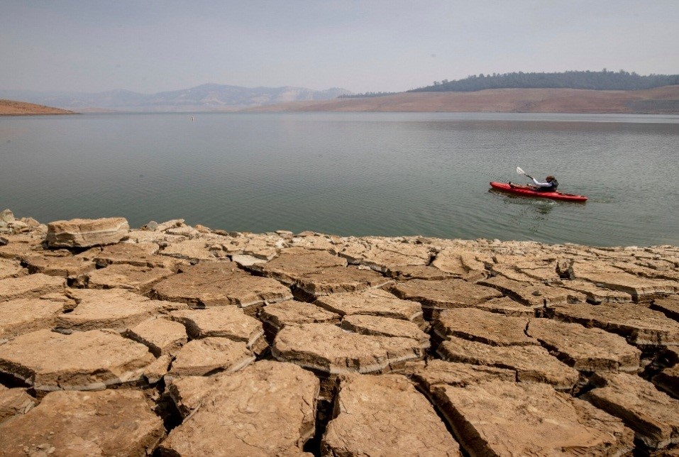
Image 1: Drought in Australia (New York Times, 2021)
Floods
Floods can fall under the weather or hydrological type of hazards. It is a natural deadliest common weather hazard. Floods are an overflow of water that submerges a dry land. It is an abnormal rise of water in a place that is uncontrollable (Ga.gov.au, 2021). Floods build up very quickly and cover anything from a few inches of water to several feet. According to the National Severe Storms Laboratory, there are several types of floods. They include; coastal floods, river floods, flash floods, inland flooding, and storm surge.
Floods occur due to several factors. For instance, water rise above the river banks occurs due to excessive rainfall and snowmelt. Heavy rains can also cause dams breakage causing floods in drylands. On the other hand, tsunami, tropical cyclones, and higher than average tides cause coastal flooding and storm surge. Lack of plantations or vegetation can also cause flooding. Vegetation usually prevents flooding by slowing runoff water. Lack of vegetation causes water from streams and riverbanks to flood.
Floods can be harmful to both vegetations, properties, and humans. It causes economic and social problems. One devasting effect of floods is the loss of lives by carrying people away or drowning them. On 9th June, 2021, severe weather which involved strong winds and heavy rains affected the state of Victoria in Australia causing severe floods. In 24hrs more that 200mm rain fell while wind gusts over 100km/hr (The Guardian, 2021). One person was reported dead in a vehicle stuck in flooded water. Also, tens of thousands residents of Victoria were left without telecommunications and power.
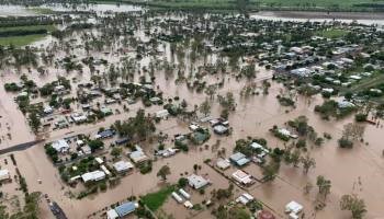
Image 2: Victoria’s Floods in Australia ( 2021)
In addition, floods cause property destructions building, roads, cars, among others. The damage and siruption of things cause a huge economic impact. Flooding can also cause water deaseas such as typhoid, cholera, and bilhazia.
Discussion
Ways of Monitoring Hazards
One of the digitalized ways of monitoring earthquakes and floods or another hazard is the use of mobile APPs. Several apps have been developed to monitor disasters. An Example of such APP is Disaster Alert. This APP was developed by Pacific Disaster Center (PDC) in Hawaii. It helps users to search for disasters that are happening, such as floods, droughts, fires, tsunamis, among others. The application also helps in tracking a virus outbreak. Other APPs include QuakeAlert, Info BMKG, and Safety Tips.
Weather Satellite images in conjunction with radar instruments which are suited for differentiating between dryland and waterlogged are used to show the whole flooded area in a single picture. The satellite can show the intensity of floods, whether they are reducing or growing with time. The data captured by satellites can provide detailed digital elevation models of the areas exposed to the risk. The images captured helps in comparisons of before and after disasters enabling a rapid estimate of damage thus factoring out the cost of the disasters. The weather Satellite also helps in predicting droughts hazards. The satellite capture thermal infrared images that gives details about the amount of heat on Earth’s surface. The information is used to estimate evapotransipiration which measures the amount of water transferred from the land to the atmosphere via the plants and soil.
GPS has been used to measure storm systems. Equipping GPS on ground-based weather stations with a new sensor network, allows researchers to track storm systems in unprecedented detail. In addition, weather balloons can be used to monitor hazards such as floods. GPS when linked with sensors, is used as a tool to evaluate and predict flash floods and earthquakes. The researchers have added seismic and meteorological sensors that enable them to monitor hazardous events in real-time. Sometimes the sensors help in predicting them before they happen.
Mitigation Strategies
Mitigation strategies are the actions taken to prevent and reduce the risk and damages caused by natural hazards. Mitigation and prevention strategies are based on the risk assessment concerning environment and landscape, essential infrastructure, land use, and building codes, among others.
Construction of floodways, channels, and Spillways
Floodways and spillways are constructed to carry water that is flooded in dry land and channel it to rivers or dams. Sometimes river channels are modified to increase the capacity of carrying the floodwaters thus reducing floods. For example in Victoria Floods case, the state government in conjuction with floodplain management authorities and municipal councils are implementing flood mitigation in Victoria to reduce the effect of such floods in future such as drainage improvements.
Water and Soil Conservation
Drought can be reduced by implementing mitigation strategies like water and soil conversation. This strategy helps in reducing soil degradation, erosion, and water pollution. The practice used to conserve water and soil include crop rotation, erosion control structures, water rentention and detention structures, tillage practices among others. Soil and water conversation is done using two approaches; engineering measures and agronomic measures (Actforlibraries.org., 2021).
Engineering measures involve establishment of check dams, percolation ponds which stores water for livestock and also recharge the groundwater. Trenches and contour bunds reduce the flow of runoff water enhancing the soil moisture by the retained water. Agronomic measures include season tillage, contour farming, deep tillage, and vegatition barriers which increase soil moisture and prevent soil erosion.
Planning and Predicting Future Hazards
There are several ways used to predict and plan for future hazards. A few examples of these strategies include;
Flood Recurrence Intervals
Researches use statistical probability to reduce floods’ risk and occurrences. The risk is usually assessed if the likelihood of a specific flood magnitude is known (Dipl.nt.gov.au., 2021). By measuring the frequency of floods of various sizes, the recurrence interval can be established. This strategy helps in planning and preventing floods.
Coastal Inundation Maps
These maps represent land elevations based on storm tide scenarios and the sea level rise. The maps help in identifying the areas that are affected by coastal flooding and understanding the impacts of inundation in such areas (Dipl.nt.gov.au., 2021). The maps help in preventing and planning for future hazards.
After the Victoria Floods in Australia, house raising is widely used to minimize the frequency of inundation of habitable floors hence reducing damages caused by flood (Ga.gov.au., 2021.
Conclusion
Natural Hazards Natural Hazards can be threatening socially and economically. The intensity of hazard is measured by the number of deaths it has caused or the cost of properties it has destroyed. Hazard assessments are done through risk assessment from a scientific point of view. Risk assessment also helps in determining the socio-economic impacts of hazardous events and how to prevent the risk. Although some natural hazards cannot be avoided, vulnerability and risk of hazards can be reduced through establishing ways of planning and predicting the hazardous event. Monitoring and developing mitigation strategies can help minimize hazardous events.
References List.
Actforlibraries.org. 2021. A Guide to Drought Mitigation Strategies. [online] Available at: [Accessed 17 August 2021]
Dipl.nt.gov.au. 2021. Flood mitigation measures. [online] Available at: [Accessed 17 August 2021].
Ga.gov.au. 2021. Flood | Geoscience Australia. [online] Available at: [Accessed 17 August 2021].
NASA. 2021. What Is Climate Change?. [online] Available at: [Accessed 17 August 2021] What really is climate change?
New York Times. 2021. Extreme Weather, Australia, Fall Books: Your Thursday Evening. https://www.nytimes.com/2021/09/16/briefing/extreme-weather-australia-fall-books.html [Accessed 16 September 2021].
Society, N., 2021. Drought. [online] National Geographic Society. Available at: [Accessed 17 August 2021].
The Guardian. 2021. Major flooding in Victoria leaves tens of thousands without power or telecommunications. https://www.theguardian.com/australia-news/2021/jun/12/major-flooding-in-victoria-with-traralgon-ordered-to-evacuate-as-creek-level-rises [Accessed 12 June 2021].